Standardization of address and location information management systems
Background to the Standardization
In order to respond to the labor shortage caused by the rapid population decline, it is essential to improve the efficiency and convenience of public service provision through the use of digital technology.
The " Basic Policy on the Development and Operation of Common Digital Platforms for the Government and Local Governments (PDF / 1,144 kb) ," approved by the Cabinet in June 2024, calls for the thorough implementation of business process reengineering (BPR) and digital principles by each government ministry and agency across the national and local governments in their respective areas of responsibility, as well as the development and utilization of a common Digital Public Infrastructure (DPI) and the promotion of common SaaS by the national and local governments to advance this business reform.
In this process, it was decided to promote "standardization," which is to build a system in the Government Cloud in accordance with the specifications created by the national government while listening to the opinions of local governments, and to provide it as a software service. This is based on the premise that standardization efforts will reduce the need to customize the function and promote data standardization.
The Address and Location Information Management System was nominated and selected as a candidate for consideration for fiscal 2025 as a business and system to be standardized by the national and local governments. (Reference: Common Standardization Candidate (selected for fiscal 2025) Proposal (National and Local Governments Digital Common Infrastructure Promotion Liaison Council Working Team (7th) Materials) (Cabinet Office) (PDF format) )
We have also received requests for standardization from local governments. ( (Reference) 2025 Proposal from Regions (Regarding the Policy of Data Maintenance below Machiaza (February 2026)) (PDF / 3,439 kb) )
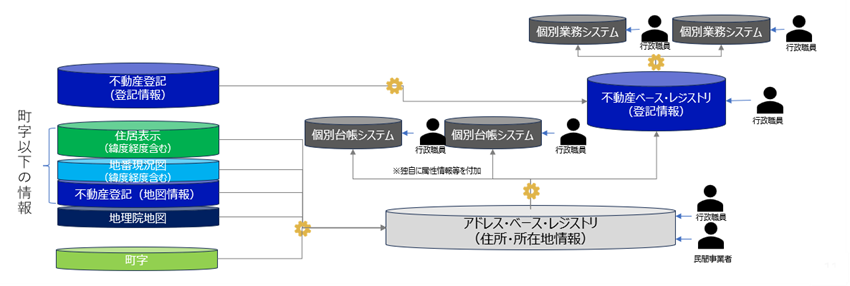
Standardization of address and location information management systems
As a result of the promotion of standardization by the national government, many cities, wards, towns and villages that currently manage their residence indication ledgers on paper will digitize them. As a result, it is expected that the work efficiency of these organizations and businesses will be improved by the development of data required by other administrative organizations and the private sector.
(Image of a common system)![[Before development (left)] There are three local governments, A (system management), B (digital management), and C (paper management), with private sector at the top. Data provision to private sector is provided through the API system (code icon), while data provision from local governments B and C is provided by paper, and the linkage method is not uniform. As a supplement, it is stated that "Many local governments manage paper ledgers, but some have already been systemized and the scope of systemization is also different." [After development (right)] "Common system (database icon)" is newly established between private sector and the API system (code icon), and is highlighted in a blue box. Local Governments A, B, and C are connected to the common system by a two way arrow of "linkage," and the data-provision route is unified. As a supplement, it is stated that "Local governments that have already introduced their own business systems will only standardize the data-provision part. Local governments that manage on paper will gradually determine the scope of standardization according to the actual situation of the existing system, such as by standardizing the business part."](/assets/contents/node/basic_page/field_ref_images/a8d1d2df-9f56-499f-ac29-0ca571bfc3b1/76bb2067/%E7%94%BB%E5%83%8F1.png)
It is also expected to simplify the administrative operations of other administrative agencies that use the databases and to improve the convenience of private sector's administrative processes. The development of the databases required by other administrative agencies and private sector will also contribute to improving the efficiency of Tokyo's administrative processes.
Implementation Image: Cases in which government officials uses registered information
- By using map information, you can search for lot numbers and properties from the residence display.
- Even for lot numbers that do not have public coordinates, the same search can be made by utilizing the zoning, numbering status, location, and shape of the land in the lot number current status map.
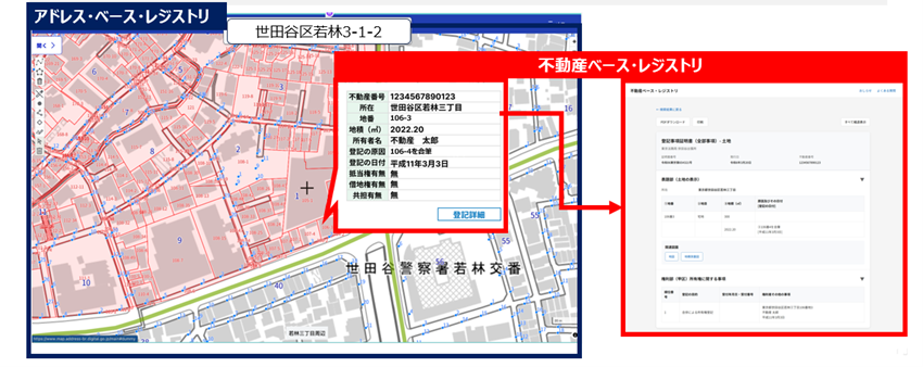
System Configuration Image
- In base registry for address, the residence indication information (block code / house number) and lot number are held including latitude and longitude so that they can be superimposed on the map.
- Within the administration, in addition to making it available to other ledger systems, as a real estate-based registry, it makes it easy to search for registration information by combining registration information.
- It is also considering providing residential indication information including coordinates and lot number information to private sector.
About the Demonstration Project
Demonstration Projects in Fiscal 2026 and Fiscal 1997
In order to verify whether the development and operation of the "common system by the national government" is feasible in terms of budget, system, and business, we will invite local governments to cooperate and implement demonstration projects through the pilot system. The demonstration projects consist of three projects: (1) development of the pilot system, (2) computerization of the residence indication ledger, and (3) business verification. Digital Agency will implement the procurement for (1) development of the pilot system and (2) computerization of the ledger. 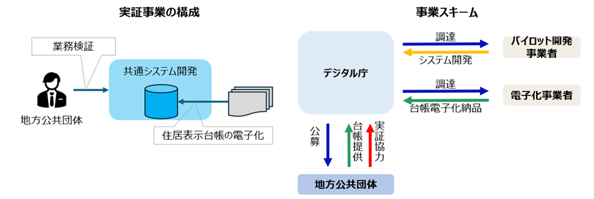
Selection of public call Groups
We received applications from a total of 125 organizations. Given the need to secure the size (number of city blocks) of the area and organization within the budget constraints for the digitization of the ledger for the verification of the common system, we set the number of selected organizations by area and size based on the number of applications. We set scoring criteria for each area and size from the perspectives of (1) whether the necessary data can be prepared, such as parcel number current status maps and background maps, (2) whether the environment for the digitization of the ledger can be established, and (3) whether a system for business verification can be built. We selected the 25 organizations with the highest scores. In addition, we have already completed the digitization of the ledger and selected seven organizations that will only conduct business verification.
For a list of selected organizations, please refer to the Selected Organizations in the Demonstration Project for the Standardization of Address and Location Information Management Systems in (PDF / 320 kb) .
Schedule
The upcoming schedule is as follows.
| When | Contents |
|---|---|
| February 2026 | Public call of cooperating organizations |
| March 2026 | Selection of public call Groups |
| Since April 2026 | Development of pilot system / Start of paper-based ledger digitization project |
| Since April 2027 | Verification of operations |
| June 2027 | Formulation of a response policy |