Base registry for address
- Last Updated:
Base registry for address is a database of addresses and locations developed as a base registry *.
*The official legal name of the base registry is defined as "Public Basic Information Database."
Notice
- March 30, 2026
- Study on the development of data (block code, house number, lot number) other than "Machi-aza", the common Address and Location Information Management System address and location information management system is shown.
- October 16, 2025
- Notes on Machi-Aza Data, the correspondence was completed and it was published in Related Information.
- June 30, 2025
- On June 1, 2025, the official version of the Machiaza data was released.
Table of Contents
- Background of the efforts
- Overview of Activities
- Future Development
- Notes on Machi-Aza Data
- Review of data development (map information) for areas other than machi-aza
Background of the efforts
Address and location information is used in many public and private ledgers, such as the addresses of individuals and the locations of corporations and public facilities. Address and location information has the structure shown in Figure 1. Currently, there is a structural problem in that the systems related to address and location are divided into two different systems, the Real Estate Registration Act and the Residence Indication Act, and they are not centrally managed by the government. Therefore, various entities, mainly in private sector, are individually maintaining address and location information, and the following problems are arising.
- Duplication of costs across society
For the same address and location information, multiple entities are conducting similar development and renewal, resulting in duplicate costs. - Burden of information collection and provision
Because each entity individually collects information from administrative agencies, there are opinions that not only the collecting side but also the providing side administrative agencies feel a burden. - Lack of data compatibility
In addition to the difficulty of linking residential signs and lot numbers, as a result of each entity developing individually, notation shaking is likely to occur, making data linkage and integration between systems difficult.

Overview of Activities
Since fiscal 2021, we have been using address / location-related data * held by the government and posting it as CSV data and disclosing it as a trial disclosure version.
*Digital Japan Basic Map (geographical name information) (Geospatial Information Authority of Japan), Locational Reference Information (Ministry of Land, Infrastructure, Transport and Tourism), Map provided by Registry Office (Ministry of Justice)
In addition, since fiscal 2023, the Provisional Digital Administration Study Group and other bodies have examined how the database should be developed and compiled development policies for the database up to Machi-aza. Based on these policies, in June 2025, we will release accurate Machi-aza database with the confirmation of local governments. From then on, in cooperation with Ministry of Internal Affairs and Communications and other related ministries and agencies, we will collect and provide updated information from local governments as needed to keep the database up-to-date. (For details, please refer to 's "Public Basic Information Database Development and Improvement Plan (PDF / 1,320 kb)" , which was decided by the Cabinet on June 13, 2025.)
* "Machi-aza" refers to "machi or aza" in the Local Autonomy Act.
In addition, it is stipulated that "the code value of the Machi-aza IDs specified in the base registry for address" Machi-aza Master Data Set "developed by " shall be set in the data item "Address _ Machi-aza Code" of each system in , which is the standard specifications of the unified and standardized data requirements and linkage requirements for the core business systems of local governments in Digital Agency. base registry for address
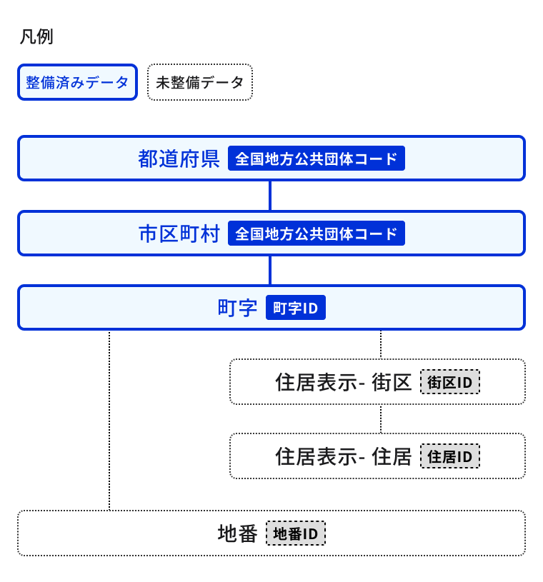
The base registry for address table has a hierarchical structure as shown in Fig. 2. At present, we have completed data preparation up to Machi-aza (character information) (blue frame in the figure).
The development policy for Machi-aza (map information) and lot number / residential indication (text information / map information) is currently being examined at the Expert Meeting for Promotion of Base / Registry. Please note that the data currently released for these is a trial release version.
Please use the date from the "base registry for address (date download site)" .
Future Development
The Expert Committee for the Promotion of Base Registry is studying policies for the development of town names (map information) and lot numbers and residential indications (character information and map information). For details, please refer to the Base Registry page.
Efforts to Promote the Use of base registry for address
In addition to publishing the town data collected in base registry for address in CSV format, ABR Geocoder (ABR stands for base registry for address), a tool for normalizing addresses and geocoding (assigning location coordinates), is also available as open source software at in in .
By using the ABR Geocoder, you can reduce the effort of matching and collating addresses and locations, and display addresses and locations with text strings on a digital map. For more information, please visit the ABR Geocoder explanation page .
Notes on Machi-Aza Data
There were some points to note regarding the "Machi-aza date" confirmed by the local government, which was released as an official version. However, we have completed our response and have started releasing the Machi-aza date with the revised points to note. Related Information. In addition, the details of the revised contents are posted in the notice of Base registry for address (Download Site), so please check it.
Study on the development of data (block code, house number, lot number) other than "Machi-aza"
For information lower than the town code (block code, house number, lot number), we are considering linking house indication information and lot number information via maps.
For details, please refer to the Standardization of Address and Location Information Management System page.
Related Information
- Base registry for address (Download Site)
- Data Format (June 2025 version) (under preparation for publication)
- Base registry for address Data Commentary (June 2025 version) (Being prepared for release)
- Terms and conditions of data
- Base registry for address Geocoder (ABR Geocoder)
- ABR Geocoder ( in )
- Kept by Ministry of Justice Registry Office Converter for converting cartographic data (mapXML) to GeoJSON ( in )
- List of Local Governments in Need of Attention regarding Machi-aza Data (Excel / 36 kb)
- List of Records to Which You Need to Pay Attention Regarding Data (Excel / 1,703 kb)
- List of records whose Town ID has been corrected [Correction of the first four digits of Town ID] (Records in the List of Points to Consider) (Excel / 1,172 kb)
- List of records whose Town ID has been corrected [Correction of the first four digits of Town ID] (Record not included in the list of points to consider) (Excel / 14 kb)
- List of records with corrected town IDs [Kyoto Street Relations] (Excel / 85 kb)
- List of Records with Corrected Town ID [Same Municipality / Same Name Town] (Excel / 25 kb)