Area Data Coordination Platform
- Last Updated:
By linking and sharing information such as administrative procedures, health, transportation, disaster prevention, and tourism between various services that support people's lives, we will provide services optimized for individual needs and promote digitalization in local communities. By utilizing information through area Data Coordination Platform, we aim to promote digital transformation in local communities and realize a society where diverse happiness can be realized.
Notice
- May 29, 2026
- Data Society Promotion Council (DSA) Seminar Information
- April 13, 2026
- Updated the Data Coordination Platform datamap creation format (version 1.2) for the Regional joint usage guidebook
- December 15, 2025
- Updated the Data Coordination Platform datamap creation format (version 1.2) for the Regional joint usage guidebook
Table of Contents
- Background:
- About Area Data Coordination Platform
- Actual Introduction of Area Data Coordination Platform
- that makes the most of
- Contact:
- Related Information
1. Background
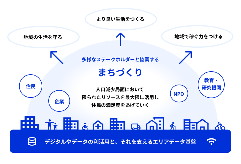
Currently, many regions in Japan are facing a phase of population decline, and the maintenance of services for residents is a challenge. Under these circumstances, in order to realize "services optimized for individuals," in which the supply side meets the circumstances of the demand side, and to improve the satisfaction of residents and revitalize local communities with limited resources, it is necessary to consider community development based on the three axes of "protecting local life," "creating a better life," and "gaining the ability to earn money in local communities."
In order to make these efforts a reality, it is essential to cooperate not only with the government but also with a variety of stakeholders, including private companies, NPOs and local residents.
In addition, in order to improve the added value of existing services and create new services for private companies and local governments, it is essential to utilize area data such as geographic data and public data, as well as data on various services that support daily life, such as administrative procedures, health, transportation, disaster prevention, and tourism.
All of these efforts are supported by digital technology and data utilization, and the Area Data Coordination Platform plays an important part in this.
In addition, for the realization of a digital society and Smart City , please also check the initiative that makes the most of area Data Coordination Platform.
2. About Data Coordination Platform
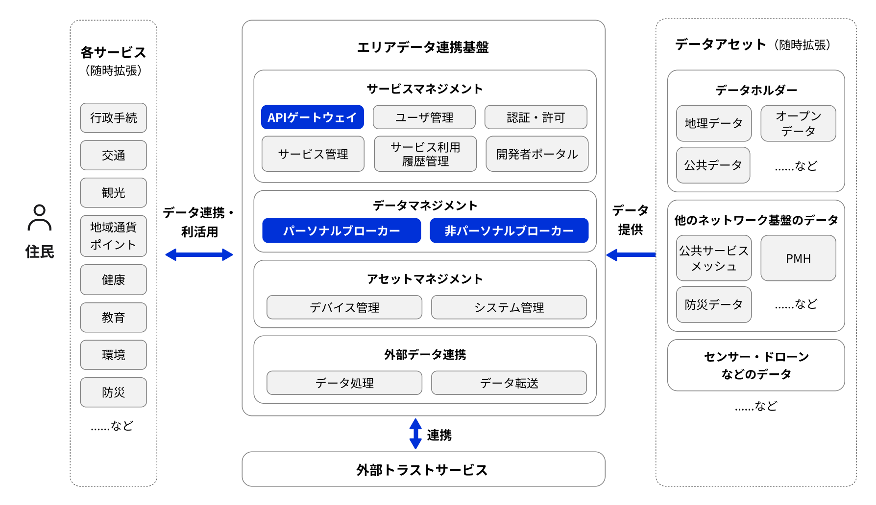
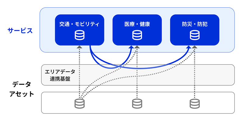
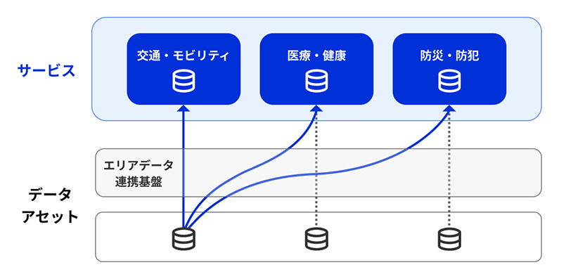
Area Data Coordination Platform is a system that aggregates local data and mediates them to various services such as administrative procedures and transportation.
As the core of a data-brokering function, we will utilize open data and other data-assets for various services. We will also promote efficient data-utilization by linking the data-held by each service. Therefore, we will demonstrate the true value of an area Data Coordination Platform by connecting many services and data-assets.
When building or introducing an area Data Coordination Platform, it is important to avoid overlapping investments in similar data-linked areas and to guarantee open specifications that are not tied to a specific service or service provider. This allows for the freedom of service design using an area Data Coordination Platform and the realization of services optimized for individuals. function
Based on this perspective, it is necessary to promote further utilization of area Data Coordination Platform while expanding their shared use in order to avoid unnecessary overlapping investment in infrastructure by local governments and to achieve sustainable operation.
Recommended Modules
In order to further promote these initiatives and promote interoperable data-sharing, we are providing a recommended module that will serve as the core of an area Data Coordination Platform.
- Broker (non-personal) "NGSI v2 FIWARE Orion"
- Broker (Personal) "Personal Data Linkage Module"
- Kong Gateway, an API gateway
Support for introduction and use
Please check the link below for the introduction and utilization support of the recommended modules and the update information of the recommended modules.
- Area and Data Coordination Platform Initiatives (Data Society Promotion Council (DSA))
- A Basic Guide to Data Coordination Platform (Data Society Promotion Council (DSA))
Seminar Information
Please check the link below for seminar information related to the area and Data Coordination Platform.
- Seminar Information (Data Society Promotion Council (DSA))
- 【 Held on Wednesday, July 1st 】 Area / Data Coordination Platform Promotion Project FY 2025 Status Report Seminar
3. Introduction of Area Data Coordination Platform
Status of Area Data Coordination Platform Utilization
Utilization status in Japan
Utilization by Local Government
Configuration of Area Data Coordination Platform
Area Data Coordination Platform Configuration (recommended module)
Area Data Coordination Platform Configuration (Usage IDs)
4. Measures to make the most of Data Coordination Platform
In order to realize a digital society and smart cities, we need the concept of "Architecture Area Architecture in Data Coordination Platform area Data Coordination Platform" and "Joint Use of Joint Use of Area Data Coordination Platform and Joint Vision" to use the infrastructure together to solve the same problem in a unified area.
Area Architecture in Data Coordination Platform
In order to promote smart cities and solve local issues, it is important to consider solutions across sectors and utilize a unified Architecture. The Smart City Reference Architecture published by Cabinet Office is a recommended blueprint that shows not only the system but also the overall framework and relationships including local governments and companies. By utilizing this reference Architecture, interoperability is ensured and smooth data utilization can be realized.
Joint Use of Area Data Coordination Platform and Joint Vision
In order to promote digital-based digital transformation in local areas, the use of data and the concept of data-driven (decision-making and problem-solving based on objective data) are essential elements.
In order to achieve this, it is necessary to utilize area Data Coordination Platform. Since considerable costs are required for operation and resources are also required for operation and maintenance, it is useful to promote joint use at the prefectural level, which has a certain regional spread, rather than introducing and operating on a single local government.
When promoting shared use, it is important to have sufficient discussions with the basic local governments in the region on how to utilize data and how to realize continuous operation, including costs, by jointly using the infrastructure, rather than being preoccupied with "building the infrastructure" or "using the infrastructure."
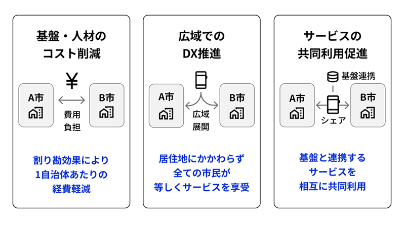
In addition, shared use has the following advantages
- To reduce infrastructure and personnel costs
- Promotion of DX in wide areas
- Promoting shared use of services
Area Data Coordination Platform Common Use Guidebook
We have published a guidebook that summarizes the issues and guidance necessary to promote the shared use of regional Data Coordination Platform and to realize services that are more optimized for individuals.
- Area Data Coordination Platform Shared Use Guidebook 2.0 (PDF / 8,227 kb)
- Organize and introduce processes for considering services, examples of data utilization, and data maps
- Include examples of open data utilization and operating organizations
Area Data Coordination Platform datamap
When considering specific data utilization, it is necessary to first identify what kind of data is held, the current utilization method, and the potential utilization possibility.
In addition, by clarifying technical conditions such as connection methods and update frequency, it is effective to grasp usable data, correct duplication and inefficient linkage, and create a data map as a basic material for future data linkage design.
The benefits of creating a data map include:
- Understanding the whole picture through visualization
- Promotion of cross-sectoral cooperation
- Improving efficiency of development and investment decisions
- Strategic Prioritization
Data Map Authoring Format version 1.3 (Excel / 177 kb) (updated April 13, 2026)
Service Side Data Map
The information that the government and private companies have for each service can be provided and used by other services and businesses that need it through the area Data Coordination Platform.
Data Asset Side Data Map
Open data, geographic data, and public data can be provided and utilized as data assets to other services and businesses that need them through the area Data Coordination Platform.
List of Visions for Shared Use (Summary of Contents of Each Prefecture)
The contents of the Vision for Shared Use formulated by each prefecture are classified, and the compiled data is shown below. A link is set for each prefecture name in the data. For details, please check the linked website.
5. Contact
Please contact us at the email address below for any comments or consultations regarding this matter.
Email: dd-rollout _ atmark _ digital. go. jp
*"@" is displayed as " _ atmark _ " to prevent spam mail. When you send mail, please change " _ atmark _ " to "@" (one byte).